 Are you still talking about Cyclone Nargis? Have you ever heard of Cyclone Nargis? Here’s a reminder: on 1 May 2008 a weakening low-pressure system suddenly picked up energy as it approached Burma from the Bay of Bengal. By the second day of this rapid strengthening, Cyclone Nargis was blowing in excess of 135 MPH and made landfall on the low-lying southern coast of Burma armed with vast reserves of cyclonic energy, a storm surge beneath, and constant heavy rain from above. The Irrawaddy Delta was devastated, causing at least 140,000 human deaths. Most of us have forgotten about it. One reason you may have heard of Cyclone Nargis at the time, is that for a short while it was the cause of a major diplomatic incident, with the Burmese Junta refusing to accept aid and assistance from the West, while continuing with a meaningless referendum. Another reason you may have heard of Cyclone Nargis is because you live near to Burma; and there’s the rub – proximity is the single most important factor in deciding whether a story is newsworthy in the mainstream media, and until Hurricane Katrina hit Louisiana in 2005, devastating coastal flooding was just something that happened to “other people” as far as the vast majority of Americans were concerned. That’s not going to change anytime soon – it’s partly down to our natural tendency for prioritizing the local and the immediate, for survival reasons; but to a large extent it is also down to the cultural conditioning that exists in most civilizations in order to only value that which benefits the system that you are deemed to be part of. If you are American then that means that anything that doesn’t affect America, doesn’t matter. You can safely repeat that mantra for any civilized nation. It’s not necessarily good, but it’s true.
In Part I of this article, we examined the best available research, In this part, we focus on two areas that are most familiar to the two authors, and also relevant to the majority of readers: Dmitry is going to look at the likely impact of future sea-level rise on the Eastern Seaboard of the USA, not just in terms of the direct effects of flooding on habitation, but the many different indirect effects that sea-level rise will have; Keith is going to do the same for the east coast of England and the Netherlands, two places that have seen their fair share of flooding in the past, and are bound to suffer in the future. The view from New England by Dmitry Orlov When it comes to addressing the effects of sea level rise that is expected to occur over the course of this century, there are many ways to immerse yourself in the subject. You might do some reading and make some field trips, talk to knowledgeable people, attend some seminars, and write some research papers. Or you might take an entire year to slowly traverse the landscape in question, and get a feel for it through a lot of direct observation, which is what I did. I spent about a year sailing around the Eastern Seaboard of North America, from the submerged coastal mountain range that is the coast of Maine north of Portland to the shifting sand dunes of St. Augustine in Florida, and most points in between, looking at both nature and historic sites along the way. There certainly is nature to be found further inland, but rather few historic sites. It is very important to understand that, unlike the ancient and compact settlement patterns of Europe, and unlike its dense and active network of navigable rivers and canals, North America consists of a rather narrow but thickly settled coastal zone known as the Northeast Corridor, and the vast expanse of Wild West. Historically, the colonies survived through ocean trade. Until the advent of coal-fired railroads, the only parts of the interior that were economically viable were the ones that were within easy reach of a navigable waterway. Even then many inland settlers found grain to be too bulky for trade, and used it to make whiskey. The Erie Canal made Chicago a town rather than just a portage between the Great Lakes and the Mississippi River. The reason was simple: before the advent of railroads, it cost as much to transport cargo 30 or so miles overland as it did to ship it across the ocean. Until a railroad was built across Massachusetts, goods shipped from Chicago to Boston via the Erie Canal had to be loaded onto barges and floated down the Hudson River to New York, then transferred to schooners that took them up the coast. It is also very important to understand that global trade is not, as one unfortunately often hears, only possible thanks to fossil fuels. Until the 1920s much of the shipping in Boston Harbour was by sail. Most of the ships were relatively small, with vast numbers of schooners of around 60 feet and crews of 10 or fewer. The age of container ships, bulk carriers, roll-on roll-offs (ROROs), and other monstrous oil-thirsty craft is quite recent, while the history of global trade is ancient, and proceeded in one of two ways: on foot (leading caravans of pack animals) or by sail. It is also important to note that coal never became competitive with sail in transporting bulk goods, and sail-based shipping persisted until the age of the marine diesel engine, which burns bunker fuel (a slightly upgraded crude oil). This substance will most likely no longer be available in the vast quantities required just a few decades from now, and certainly well before the end of the century. It seems plausible to think that the age of fossil fuels will end as it started, with oil giving way to coal, giving way to wind. And so, in looking at the future of North America, it makes sense to examine historical settlement patterns and patterns of trade. Even after the powerful economic stimulant of fossil fuels is no longer flowing freely, the perennial choice will remain the same: make and ship trade goods, or remain backward and poor. The transportation options will once again be largely limited to the waterways, with the vast landlocked areas of North America becoming stagnant backwaters, unable to trade, and steadily depopulating. Many people look at the end of the fossil fuel age and envision a future that is much more local; and surely it will be, but what they do not envision is the effect of a radically altered transportation topology. The current tightly interconnected transportation mesh of rail links, highways, and airports will be gone; and in its place will arise a sparse, seasonal network favouring single modes of transport for each link (pack animal, river barge, or ocean sailboat), heavily weighted in favour of water transport, and even more heavily weighted in favour of sail. Transporting a few tons of cargo per crew member across the Atlantic will require a few weeks' worth of rations for the crew members and a bit of sailcloth for the ship, but the wind will still be free. Hauling the same amount of freight across the Appalachian mountain range, which runs the length of the Eastern Seaboard, would become something of an epic undertaking. Looking, once again, at the historical settlement patterns along the Eastern Seaboard, it becomes clear that how prosperous and populous any given coastal settlement becomes has a lot to do with how good a harbour it has. The Carolinas present an excellent example of this: their climates and populations are broadly similar, yet North Carolina is poor while South Carolina is prosperous. The difference can be brought down to a single, overwhelming factor: South Carolina's Charleston Harbour. This is a splendid deep-water harbour, sheltered, with a wide inlet. North Carolina is dominated by Cape Hatteras, an area of shifting shoals and wide, shallow bays. To make matters worse, the Cape brings together the warm Gulf Stream, flowing north and turning east, with the terminus of the cold Labrador Current flowing south, and the mixture of the two creates a lot of unsettled weather. To make matters worse yet, it is within reach of tropical cyclones, which shift sand dunes, close and open ocean inlets, and play havoc with coastal communities that depend on access to the ocean. While Charleston Harbour is a major asset, Cape Hatteras is a world-class hazard to navigation. And so South Carolina grew rich by importing African slaves and exporting rice, indigo, and cotton through Charleston Harbour; while North Carolina, with its many shoals and few and treacherous navigable ocean inlets, developed no major towns and subsisted largely through fishing. I've looked closely at many of the successful port towns, large and small, along the Eastern Seaboard: Portland, Newburyport, Salem, Boston, Newport, New York, Charleston, and St. Augustine, plus a few others. All of these have accumulated centuries of history, much of it connected with the sea and, hence, with faraway peoples and places, and this makes them major tourist destinations. The quality of the harbour, it turns out, had much to do with the relative success of a port: Boston's excellent harbour, with a wide channel and ample anchorages with good holding ground in the lee of a good set of sheltering harbour islands, allowed Boston to compete with New York in transatlantic trade. But beyond geological luck, something else stands out: the quality of the transition between water and land. In every good port there are dredged and marked approaches to piers and jetties, good seawalls high enough to keep out most storm surges, and dry land beyond, which is solid and graded flat. Over its long history as a port town, a hilly town, such as Portland, Boston, or New York, slowly grows an apron of land that is just high enough to be out of reach of most waves. Although some of these shoreline reinforcements are the result of ambitious projects (the cut-stone embankment in Newburyport is a good example), many of them are the result of a slow process of accretion by generations of people plying maritime trades, adjusting the shoreline to different uses by floating in and dumping rip-rap and solid fill, building seawalls, jetties and piers, seeing them pruned back by storms, and learning their lessons. Just how close to the margin these old structures already are became apparent to me last summer: during high tide, and thanks to the extra two feet of water we got for no adequately understood reason, some of the older, abandoned piers in Salem, Massachusetts were awash. Most of these structures have been designed hundred-year floods in mind, presumably because having to rebuild them every century or so is not such a bad thing. But then, given the expected ocean level rise, every hundred years will become every 10, then every year, and then every neap tide, then every high tide when there is an easterly wind, and then permanently awash at high tide. Who would be up to the thankless task of piling up more rocks and driving in more pilings, just to see them washed away a decade or so later? A related problem is the silting up of channels caused by accelerated erosion. Once waves can reach a stretch of land that hitherto only had to contend with rainwater and snow melt, it often dissolves catastrophically, and what was for centuries a waterside pasture or marshland protected by a bit of rock is transformed within a season or two into a gradually sloping mud flat. The mud then gets scoured out by each tide and settles in the deepest spots, which are the navigation channels. At what point everyone will decide that all of this very temporary shoring up and dredging is just too much work is entirely unclear, but it seems likely that enough other problems will occur at the same time to make the question moot. As we prepare to say "hello" to the rising waters, we should also prepare to bid "adieu" to deep-draught dockage. What other problems might we have? The United States Environmental Protection Agency was nice enough to publish some approximate maps, colour-coding the results of an ocean level rise of up to 1.5m as red and up to 3.5m as blue for the entire Atlantic coast of North America. Since I am particularly well-acquainted with Boston, that part of their map drew my attention first. The resolution is not very high, but sometimes precision is superfluous. If you expect to find yourself standing on the corner of Commonwealth Avenue and Massachusetts Avenue in 2050, should you expect the water be up to your navel, your nipples, or your eyeballs? Certainly, this would not be the map to consult on that particular occasion, but then would that be a time to consult a map at all? Broad brushstrokes are perfectly fine for the purposes of this discussion, just as a wrecking ball need not be swung with any great precision. But to start with, here is a neat and tidy map of Boston within its current shoreline. Entering Boston Harbour from the Atlantic, we pass between Deer Island with its sewage treatment plant on the right and Long Island on the left. We proceed down the main channel into the inner harbour, passing between City Point on our left and Logan International Airport on our right. Past that, on our left we find the port of South Boston, which handles container ships, and the World Trade Centre, where cruise ships dock, while on our right is East Boston with its one remaining shipyard and marina, but where once the mighty clipper ships for the China tea trade were built. Further down the channel, we round the downtown with its skyscraper-studded financial district on our left. To our right is Mystic River, which has a liquefied natural gas tanker terminal, a dock for scrap iron barges, and a car ferry port. Turning further left, we pass Charlestown Navy Yard and the Charles River Dam (which should have properly been called the Charles River Pumping Station). Beyond is the Charles River Basin, ringed by lovely waterside parks, which, on good days and bad, are full of bicyclists and joggers. The river itself is also normally quite full of sailing dinghies, rowing sculls, canoes, and kayaks. Three large universities — Massachusetts Institute of Technology, Harvard University and Boston University — are located right on the river, and each has a boathouse. (Northeastern University is landlocked, but has a boathouse nevertheless.) 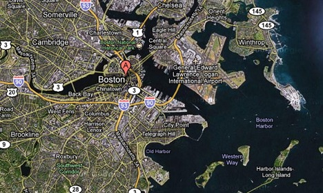 Before the Charles River Dam was built, Charles River was brackish and tidal, and smelled rather bad. The pumping station houses several large diesel engines that drive turbines that pump down the river during high tides and heavy rains, to prevent the river from leaving its banks. I have spent a year or so living at a marina directly downstream of the dam, and have observed that the pumping station does not run very often, but when it does it is quite an impressive sight. The tidal range is about 3 metres, and so with a 1.5-metre rise it would have to be running over half of the time, a 3m rise would force it to run continuously, and a 4m rise would likely put it underwater for good. And here is the map prepared by our friends at the EPA. What's red goes under at 1.5 metres rise, what's blue goes under at 3.5m rise, tan is either dry or uncovers at low tide at 3.5 metres rise (distinction not shown), and light blue is currently water. As we enter the harbour, Deer Island on our right is now again an island because the dam connecting it to the town of Winthrop is gone, as is much of Winthrop. Long Island, the barrier island on our left, is mostly washed out as well. Logan International Airport still has its control tower above water, but now only caters to sea planes. Port of South Boston and World Trade Centre are no more; same with East Boston's shipyard facilities. Downtown stands as an island, but is rather hard to reach because all the highway tunnels are underwater, as are the docks. Mystic River facilities are gone as well. Charles River Dam is out of commission, and Charles River Basin is once again brackish and tidal all the way upstream to Watertown (off the map to the left), so-called because it has another, smaller dam, and supplied all of Boston's water before an aqueduct was built to a reservoir quite far away. Prior to closing their doors, MIT, Harvard, and Boston University have spent the remainder of their rapidly dwindling endowments on dikes, dams, and pumping stations, to no avail. 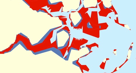 To be perfectly candid, looking at this map does not fill me with optimism for the future of our fair City on a Hill. It seems that in due course it will turn into a landscape studded with abandoned wrecks of buildings standing knee-deep in a swirling colloidal suspension of excrement and garbage. What are the chances of preserving road access, or the electric grid, or water and sewer services under such conditions? And is it worth anyone's trouble to even try, if it is understood that another decade will bring another few centimetres of ocean level rise, and that in response the shoreline will move a few kilometres further inland? Would it not be wiser to abandon entire areas as the water comes in, understanding that once it is in, it is there to stay? But that leaves open an important question: What about Boston as a port? The same question applies to any other port, or, for that matter, just about any stretch of shoreline, for, as we will see in Part III, Boston's case is quite typical. Suppose you are a planter, happily growing wheat close enough to the coast to walk it down to the waterline with the help of some mules, and you would like to exchange that wheat (baked into hard biscuits and packed in waterproof tins) with some sailors in exchange for a few bottles of wine, some chocolate, and some silk cloth for a bridal gown (life goes on, you know). You pack the tins in panniers, strap the panniers onto your mules, and walk in stately procession toward the coast (mules aren't exactly swift animals, and 1 mile per hour is what they generally peg out at). With port facilities permanently submerged, where do you intersect with your sailor friends to effect the exchange? Things are not as hopeless as they would seem. After all, we did manage to colonise the entire planet using sailboats and without any port facilities to start with. A variety of techniques, some ancient, some decidedly twenty-first century, can be brought to bear to solve this problem. The problem most people face in adapting to the rapidly transforming landscape is not technical but psychological: they will insist on attempting to run their existing systems until they crash, simply because they have so much invested in them. This will mean that most people will simply deal themselves out of the game, and that the volume of global trade will diminish, perhaps by several orders of magnitude. But it will not stop altogether, and may eventually recover somewhat. In The European Lowlands by Keith Farnish Walking the grassy embankment between the tidal River Orford and the dusty fields of East Suffolk, it becomes starkly clear what sea level rise would mean to this part of the English coast. As I walk northwards the brackish water laps the broken-down concrete sills and oozes through the cracks, eroding away silt from the dike that I am striding along. Marsh Samphire seems to glow in the October sun; a tasty treat, but rare enough to be a delicacy in these parts. To my left, a cloud of dust is whipped up by the breeze, helped on its way by the harrows of a tractor: it’s been a dry month, and the frail earth is easily moved by the action of the wind. Weak, exhausted soil; the result of decades of relentless tillage in a land that is dependent upon constant drainage via a highly complex system of ditches and waterways. The land here may be flat and low, but there is enough height on Orford Ness to mean that I can’t make out the North Sea, even from the top of this dike. But I can hear it as it washes through the stones that make up this ephemeral spur of land and then pulls back, moving the shingle in eddies down the coast. Farmland to my left; seas to my right – what must the people who live here think? Constant dread, would be one expectation; but somehow I don’t think that is the case. If we make our way 100 miles north-west to the Fenlands of Cambridgeshire and Lincolnshire, then we experience a world of sea-level denial:
Stern warnings indeed, but calmed by the claims of the Middle Level Commission; something we also see for another of the large Internal Drainage Boards (IBDs), that of South Holland, a 95,000 acre part of Lincolnshire, which states: "Although the entire area is at considerable theoretical risk of river flooding and inundation from the sea, the actual risk is substantially reduced by the work that we do in partnership with Local Authorities, the Environment Agency and Natural England." Everything will be fine if they do their job? There is a clue in the word “fine”, as the balancing act between inundation and successful drainage rests on the finest of lines; something you can easily see if you enter a very conservative 2 metre sea level rise into the Firetree global flood map: 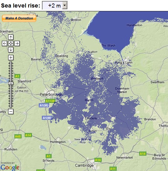 That’s the Fenlands gone, then, in all practical sense. Plug in something approaching the more dramatic scenarios discussed in Part One of this series, and you see what can only be described as an entirely new landscape: a 5 metre rise creates a larger North Sea, extending southwards to Cambridge, and taking a five mile slice off the Lincolnshire coast. No more holidays in Skegness and, probably more significantly, about 10 Gigawatts of electricity generation capability (about 15% of the UK total) is at or below sea level. That’s just in one particular part of England; on a larger scale, given the propensity for nuclear power stations to be on the coast and coal-fired power stations to be near rivers (for cooling water), a five metre rise in sea level would pretty much have the UK’s power supply bollixed. You won’t see that in any official reports. Back to the fertile croplands of the Fens, and neither will you see this startling fact mentioned: the pumping station at St Germans, two miles south-west of Kings Lynn, is just about the only thing preventing the aforementioned 170,000 acres of Fenland (the Middle Level) from flooding, even without sea-level rise. It would only take a power failure during a heavy period of rain or a high spring tide, with the sluice gates down, to quickly engulf the area. With a 5 metre rise, the new state-of-the-art system – due to be completed in 2010 – will be underwater all the time . With a storm surge, like that experienced in 1953, a mere two metre rise should suffice to flood the whole of the Middle Level, with the St Germans pumping station sputtering to an ungainly halt. If you want to see the one thing that lies between safety and the flooding of 265 square miles of land, click on this link. Comforting, isn’t it? Do you know what it would mean to bring marshland back to the East of England on the kind of scale envisaged with just a modest sea-level rise? Not only will the land become unstable for the majority of buildings currently in the area, and totally incapable of supporting agriculture of any kind beyond sheep grazing; the Fenlands, the Broads, and the East Suffolk, Essex and Kent coasts will experience the unwelcome return of malaria. Malaria in the UK; something that up until the urgent Canutian shoring up of the coast in the 19 c. was tolerated as an occupational hazard by the few who lived there, but would be a scourge upon modern towns and cities. As MJ Dobson writes, in a sobering paper on the incidence of malaria in England:
A marshy land experiencing rising temperatures: this could be any coastal region in the world, coming to a time near you. Dutch Denial Never underestimate the Dutch: apart from being a race of phenomenally linguistic people who have found an almost perfect social balance between freedom and responsibility, at least compared to the rest of the civilised world, they also manage to keep a level head when a fifth of the Netherlands is only inhabitable by humans because of thousands of miles of dikes. I suppose when you have to squint far into the past to see the deadliest of floods experienced by your people, knowing that in the last 100 years only one flood event has taken a significant number of lives, then a feeling of safety is bound to embrace you to a certain extent. But what if you do peer back? 1717 is regarded as the year of the last great flood in the Netherlands; the Christmas Flood which is estimated to have led to the deaths of 14,000 people in a single night. Return to 1570, and the All Saints flood is said to have taken many thousands of lives. Similarly in 1530, 1421, 1404, 1287... St Lucia’s Flood in 1287 washed away between 50 and 80 thousand rural lives in the low-lying central plains of Holland. Back and back, a pattern of death that should serve to haunt the cultural memories of the Dutch – it really should, regardless of how safe things may feel at the moment:
This paragraph, from E. and R. Littell’s “Living Age” (1848) predates any major engineering works, apart from the piecemeal implementation of thousands of local dikes, which were only ever meant to provide temporary respite from flooding. A remarkable plan, albeit primarily motivated by the desire for more farmland and population space, appeared in Modern Mechanix in 1930 (courtesy of the Strange Maps Blog), proposing the construction of a 450 mile long, 30 metre high wall across the central North Sea, with another slightly smaller one curving every which way to block off the southern end. 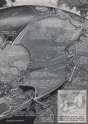 Absurdly impractical, as well as ecologically and politically ruinous, perhaps; but the construction of the Afsluitdijk (literally “Closure Dike”) across the mouth of the 2,000 square mile Zuiderzee between 1927 and 1933, was certainly close to the limits of engineering in that period, and is still the largest single land “reclamation” project ever completed. The word “reclamation” is quoted intentionally, for what exactly is “reclaimed” when the oceans are banished from a place where they once existed? This assertiveness, the almost messianic approach to claiming for a nation what was never its property, is foolhardy at best, and pathological at worst. What was once ocean can never truly be land unless the cycles of the climate deem it to be so – and we are undoubtedly taking them in the opposite direction. If we willfully claim ascendancy over the incumbent waters, as the Dutch and the British have done over the last 800 years or so in their respective lowlands, then eventually the mindset that dominates is one of impregnability. But the waters will return, not only to the coastline of eastern England as the sluice gates fail, but also to overtop the Afsluitdijk which is just 7 metres high. Remember back in Part One, when the 1953 flood reached 4.55 metres above the Normal Amsterdam Water Level? Well, the risk is increasing all the time; not only as the sea level rises, but as the energy in the oceans increases and – something that is the epitome of risk – the population grows inexorably. The denial culture that blossoms behind coastal defences is alive and well in the Netherlands, according to Maaskant, Jonkman and Bouwer:
(“Future risk of flooding: an analysis of changes in potential loss of life in South Holland”, Environmental Science & Policy, 2009) “Reclaimed land” is an anachronism because you cannot reclaim what you never had – the sea will reclaim the land soon; sooner than you can imagine. * * * For a while yet, coastal destruction caused by sea level rise will be seen as something that happens to someone else, somewhere else (or to you, but then that's just your bad luck). Social inertia will follow its usual course, causing people to insure themselves against fires and other minor accidents, sweat the little details of public health and safety, fight terrorism, while steadfastly ignoring the elephant in the room that is about to sit down on their heads. At what point will it become obvious to just about everyone that the gods saw their plans, laughed at them, and then canceled them? Will it then be too late to do anything to prepare, or will those near the coast simply join the ranks of environmental migrants? And if you do start taking steps to prepare now, will you be viewed as a harmless eccentric, an alarmist crackpot, or a dangerous subversive? In response to these questions, we are sure to hear a chorus of "Gloom and doom!" Ah, the "doomers" and the doomed, what beautiful music they make! Be that as it may; In Part III of this series, we will leave questions of denial and social inertia and political climate nonsense behind, and concentrate on What Might Work. * * * * * Editor's note: As serious as the above discussion of sea-level rise is, forcing us to imagine what looks like inevitable inundations of disastrous proportions, it does not figure in the factor of the Greenland ice sheet's or Antarctica ice-shelf's rapid contribution to sea level rise. See the excerpt below of yet more alarming news. The acceleration of melting and slippage is out of control, folks. But don't toss your computer or your car keys -- if you're fighting fire with fire in your use of technology to help save the Earth. - JL A Warming Arctic: Everyone knows that the ice sheet on Greenland is melting. But new research shows it is disappearing much faster than previously thought. The findings could mean that ocean levels are also rising more quickly. The dimensions of this frosty giant go way beyond human imagination. With a surface area spanning some 1.7 million square kilometers (656,000 square miles), a view of Greenland's ice above the Sermeq-Kujalleq glacier near Ilulisat makes it seem endless. The idea that this sheet of ice, which is up to three kilometers thick in parts, is melting seems absurd in the extreme.
Were Greenland to lose all of its ice, sea levels would rise some seven meters higher than today's levels. Such a scenario will not become reality overnight -- indeed the process could last hundreds of years. But new results from a team of Dutch researchers suggest that conservative estimates as to the speed with which the ice is melting should be shelved. According to the study, the rate at which Greenland's ice is melting has accelerated substantially in recent years... [see nine photos and read whole article at www.spiegel.de]
Part One of this series: The Oceans are Coming Dmitry Orlov other articles on Culture Change can be accessed here Keith Farnish's other articles on Culture Change can be accessed here
|
|||
|
|
||
|
|